By the Numbers
By the Numbers: How Long Could a 4.5-Mile Coastal Walk Take?
A National Trust route is 7.2 km with a 3h30 estimate. Compare transparent walking-pace scenarios and learn what a simple travel-time calculation misses.

A coastal walk can look short on a map and still take most of a morning. In a Which? feature dated 24 September 2026, one highlighted Seven Sisters route links to the National Trust's description of a 4.5-mile (7.2 km) walk. The National Trust route page estimates 3 hours 30 minutes. Here is how to use the Calcul8 Travel Time Calculator to understand that estimate, and why route-specific guidance remains more informative than a distance divided by speed.
The two numbers to start with
The route operator lists 7.2 km for the full circular walk and 3h30 as its duration. The path crosses grassy slopes, fields and coastal ground. Its terrain notes mention short steep climbs, stiles and gates, with muddy conditions possible in winter. A general-purpose time calculator does not know any of those details.
Which? is the recent editorial hook; the National Trust is the primary source for this route's distance, duration and terrain. The route page has no clear publication date displayed, so the figures were checked on 29 September 2026 rather than presented as new measurements from this week.
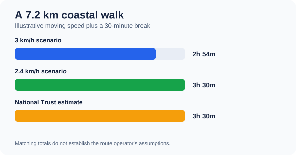
Chart note: The 3 km/h and 2.4 km/h paces and 30-minute break are Calcul8 examples. Only the 7.2 km distance and 3h30 route estimate are supplied by the National Trust.
Run a simple time scenario
On the Travel Time Calculator, enter 7.2 for distance. The form labels distance in km and speed in km/h; do not type 4.5 as though it were kilometres. Enter an illustrative average moving speed of 3 km/h, 30 minutes of breaks and 09:00 as departure time.
The moving-time formula is distance ÷ speed. Here, 7.2 ÷ 3 = 2.4 hours, or 2 hours 24 minutes. Add the illustrative 30-minute break: 2 hours 54 minutes overall, with an estimated arrival of 11:54. This arithmetic is useful, but it is 36 minutes shorter than the route operator's 3h30 estimate.
Now change the average speed to 2.4 km/h, keeping the same distance and break. Moving time becomes 3 hours, so the total is 3 hours 30 minutes and arrival would be 12:30. This matches the published duration numerically. It does not prove that the National Trust assumed a 2.4 km/h walking speed or a 30-minute stop. Many combinations of pace, pauses and route conditions can produce the same total.
The current general-purpose calculator describes its movement result as “driving time”. For this walking example, read that field as distance divided by the speed you supplied. The calculator does not switch into a hiking mode or model hills automatically.
How to interpret the pace
An average moving speed of 3 km/h is an input, not a claim about an average visitor. For comparison, at 2 km/h the 7.2 km route would take 3 hours 36 minutes moving, before any breaks; at 4 km/h it would take 1 hour 48 minutes moving. These examples show sensitivity to the assumed speed. They are not suggested targets.
The same calculation can be reversed if you are only analysing numbers: 7.2 km ÷ 3.5 hours is about 2.06 km/h as an overall distance-per-hour figure. That figure incorporates whatever stops and slow sections are implicit in the full published duration, but it is not a measured walking pace. Using it as a speed input and adding a separate break would count stopping time twice.
Why a path estimate is not just division
A route description may reflect climbs, uneven footing, navigation, gates, photos, rest stops or access arrangements. The National Trust's access section notes steep hills, stiles and a step over a wall. Its current page is also the place to check practical route details; conditions and access may change. We do not infer a safe travel time or an accessible alternative from the calculator result.
The Which? article highlights seven walks selected from members' reported experiences. Its star ratings are a survey of those respondents, not measurements of walking speed. The full King Charles III England Coast Path is a much longer network. This example concerns one specific 7.2 km circuit and should not be confused with walking an entire coastal section.
Try your own numbers
Use the Travel Time Calculator with the length of your proposed route in kilometres, a pace that reflects your own planning assumptions, and separate break time. Compare its output with the route operator's stated duration, opening information and terrain notes. If a source gives miles, use the Unit Converter first. The Time Duration Calculator can help compare a planned departure and return time.
For journeys with transport costs as well as travel time, see How to Calculate Cost per Mile. That is a different question from this walking-time example.
Sources and image note
- Which?, seven walks on the England Coast Path, 24 September 2026: recent editorial context. Accessed 29 September 2026.
- National Trust, Between the South Downs and the sea walk: distance, duration, terrain and access. Undated page checked 29 September 2026.
- The header picture is an original conceptual coastal image, not a photograph of the exact route. The in-article comparison graphic uses the stated source numbers and labelled illustrative inputs.